Showing posts with label England. Show all posts

Saturday 1 April 2023

Castlerigg Stone Circle: A Mysterious Megalithic Site in England

 Castlerigg Stone Circle is an enigmatic and ancient megalithic site located in the Lake District National Park in Cumbria, England. It is one of the most impressive and well-preserved stone circles in the country, and its origin and purpose remain a mystery to this day. In this article, we will explore the history, significance, and mysteries surrounding Castlerigg Stone Circle.

Introduction

Castlerigg Stone Circle is a megalithic site located in Cumbria, England. It is an ancient monument consisting of 38 stones arranged in an oval shape, and it is estimated to have been constructed around 3200 BC, making it one of the oldest and most impressive megalithic sites in England. The purpose of this article is to explore the history, significance, and mysteries surrounding Castlerigg Stone Circle.

The History of Castlerigg Stone Circle

The Construction of Castlerigg Stone Circle
The construction of Castlerigg Stone Circle is believed to have started around 3200 BC, during the Neolithic period. The stones used to build the circle were sourced locally, and their transportation and placement must have required a significant amount of skill and organization.

The Age of Castlerigg Stone Circle
Castlerigg Stone Circle is estimated to be around 5,000 years old, making it one of the oldest megalithic sites in England. The circle predates Stonehenge by about 1,000 years and is believed to have been used for a range of purposes, from ritualistic gatherings to astronomical observations.

The Evolution of Castlerigg Stone Circle
Castlerigg Stone Circle underwent several changes and additions over the years, with some stones being removed and others being added. In the early 20th century, several stones were re-erected to restore the circle to its original state.

The Possible Builders of Castlerigg Stone Circle
The identity of the builders of Castlerigg Stone Circle is unknown, but they were likely the prehistoric people who inhabited the area at the time. It is believed that these people had a complex society with sophisticated knowledge of astronomy, geometry, and engineering.

The Significance of Castlerigg Stone Circle

The Alignment of Castlerigg Stone Circle
Castlerigg Stone Circle is aligned with the surrounding mountains and landmarks, including Skiddaw and Blencathra, suggesting that it may have been used for astronomical observations or as a marker for the changing seasons.

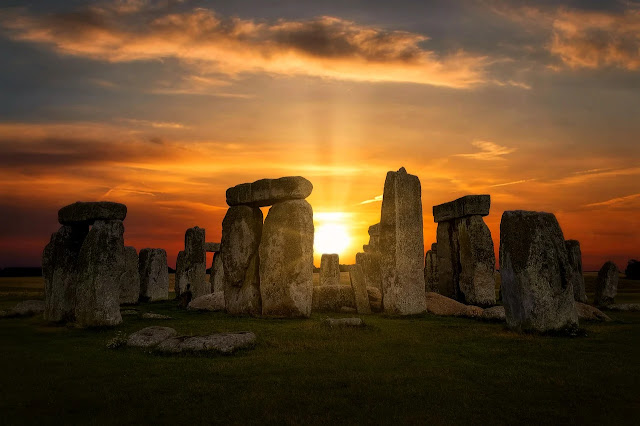
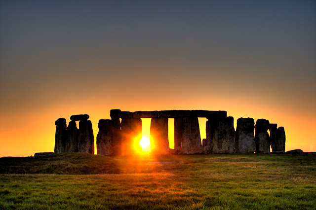
The Connection of Castlerigg Stone Circle to the Sun and Moon
There is also evidence to suggest that the Castlerigg Stone Circle was used to mark the positions of the sun and moon. During the winter solstice, the rising sun aligns with the tallest stone in the circle, while during the summer solstice, the setting sun aligns with another stone.

The Ritualistic Significance of Castlerigg Stone Circle
Many researchers believe that Castlerigg Stone Circle was used for ritualistic purposes, including religious ceremonies and burials. The circle is thought to have been a sacred site for the prehistoric people who built it, and it may have been used as a place of worship or for communal gatherings.

The Role of Castlerigg Stone Circle in Prehistoric Society
Castlerigg Stone Circle is just one of many megalithic sites found across Britain and Ireland, and it is believed to have played an important role in the prehistoric society of the time. These sites are thought to have been a way for people to connect with the landscape and the natural world, and they may have served as a way to reinforce social ties and beliefs.

The Mysteries of Castlerigg Stone Circle

The Purpose of Castlerigg Stone Circle
Despite extensive research into Castlerigg Stone Circle, the purpose of the site remains a mystery. While it is believed to have been used for a range of purposes, from astronomical observations to religious ceremonies, its true meaning and significance are still unclear.

The Function of Castlerigg Stone Circle
Similarly, the function of Castlerigg Stone Circle is not fully understood. While it is believed to have been a significant site for the prehistoric people who built it, the specific role it played in their society remains unknown.

The Cultural Significance of Castlerigg Stone Circle
Castlerigg Stone Circle has also become an important cultural symbol, representing the ancient history and heritage of the British Isles. It has inspired writers, artists, and musicians, and it continues to capture the imagination of people from all over the world.

The Legend of Castlerigg Stone Circle
According to local legend, the stones of Castlerigg Stone Circle were once a group of dancers who were turned to stone as punishment for dancing on the Sabbath. While this story is unlikely to be true, it highlights the enduring fascination and mystery surrounding the site.

The Current State of Castlerigg Stone Circle

The Protection of Castlerigg Stone Circle
Castlerigg Stone Circle is protected by law and is a scheduled monument, which means that it is illegal to damage or interfere with the site in any way. The circle is also surrounded by a low fence to prevent visitors from climbing on the stones.

The Preservation of Castlerigg Stone Circle
In recent years, efforts have been made to preserve Castlerigg Stone Circle for future generations. The site has undergone several restoration projects, including the re-erection of some of the stones and the removal of vegetation that could damage the site.

The Tourist Attraction of Castlerigg Stone Circle
Today, Castlerigg Stone Circle is a popular tourist attraction, attracting visitors from all over the world who come to marvel at its ancient beauty and mystery. It is also a site of spiritual significance for many people, who come to meditate or hold ceremonies in the circle.

The Future of Castlerigg Stone Circle
As a unique and important part of Britain's cultural heritage, Castlerigg Stone Circle will likely continue to be protected and preserved for future generations to enjoy. Its mysterious history and significance.


A591 road England

 The A591 is a prominent thoroughfare located in Cumbria, a region in northwestern England, that traverses almost the entirety of Lake District National Park. According to a survey conducted in 2009 by satellite navigation company Garmin, the segment of the road between Windermere and Keswick was voted as the most popular route in the entire United Kingdom. Furthermore, car rental firm Avis determined that the 29.8-mile stretch from Kendal to Keswick has the highest driving quality in the UK, based on their specially designed driving ratio.

The journey begins at the southernmost point of the road, which is situated 3.5 miles (5.6 km) northwest of junction 36 of the M6 motorway, at Brettargh Holt roundabout, where it meets the A590 road (54.2746°N 2.7605°W), close to the stunning Sizergh Castle. After bypassing the town of Kendal as a dual carriageway, which cost £1.9 million to construct and covers 3 miles (4.8 km), it transforms into a busy single-carriageway road upon entering the Lake District. Following the north-eastern bank of Windermere, the road bypasses the town of Windermere and traverses the heart of Ambleside, then follows the northern side of Rydal Water, passes through White Moss Common, follows the eastern edge of Grasmere and eventually past the village of Grasmere. Continuing over Dunmail Raise and along the eastern edge of Thirlmere, the road shortly leads to the town of Keswick, where it meets the A66 road at a grade-separated junction.

Subsequently, the A591 is temporarily replaced by the A66, which takes drivers westward for 2.2 km, to a roundabout where the A591 resumes and heads in a roughly northwesterly direction, boasting magnificent views over Bassenthwaite Lake. The journey comes to an end at the village of Bothel, where it meets the A595 road (54.7357°N 3.2733°W). The section of the road from Bothel to Keswick is particularly narrow and contains many acute bends, requiring extra caution when driving.

On December 5, 2015, the road was severely damaged during Storm Desmond, which resulted in a part of it being washed away at Dunmail Raise and a landslide adjacent to Thirlmere. The closed section between Grasmere and Legburthwaite was reopened on May 11, 2016. During the road closure, a new tarmac path for walkers, cyclists, and horseriders was constructed to the west of the road at Dunmail Raise.


Friday 11 March 2022

The Solstice at Stonehenge

WHY NOW Watch the sunrise over Neolithic stones, along with druids and dawn-seekers WHERE Stonehenge, Wiltshire DATES Summer solstice, usually 21 June The celebrations to mark the longest day of the northern year date back to pre-Christian times and inspire various rituals, from fertility rites to invocations of future agricultural success.

One of the most famous summer solstice celebrations is at England’s Stonehenge. From 1972 to 1984 neo-druids and other alternative communities converged on the Neolithic stone circle for the Stonehenge Free Festival but in 1985 a clash between riot police and travelers setting up the festival led to the site being off-limits for solstice. Thankfully, it reopened in 1999, and the spiritual dawn now attracts more than 20,000 people.

The Solstice at Stonehenge gives the worshippers of the Sun a chance to see something they've never seen before. In addition to that, it is also one of the best times for making some impressive photos on your iPhone. The Solstice at Stonehenge is a time when time stands still and people can experience peace and harmony with nature. 

The ancient monument in Upper Swell, Salisbury, is one of the most impressive places for festivals. The Solstice at Stonehenge is the summer season's most important event for celebrating the longest day and shortest night of the year. This was a popular tradition for early Britons, who celebrated this event annually as part of their religious life. 

The celebration also incorporated other winter solstice events, like Fire-Festival and Animal Fertility Festival. The Solstice at Stonehenge is one of the most important events in history. It is an ancient and unique winter solstice festival for those who live in Britain. The ancient Druids used to perform a ritual to mark the shortest day and longest night on the solstice. 

This ritualistic event happens annually and this year also brings in its own set of celebrations with spectacular 17th-century buildings, like Stonehenge, still intact. Stonehenge has been a significant part of British culture since prehistoric times. It was built around 3000 BC and has continued to be significant ever since then, even now that it looks largely identical to its original form. 

Source - CP


Monday 3 May 2021

Hadrian’s Wall - Hexham, Northumberland, England

Here legions once marched, sheep now peacefully graze. A few sections are all that remain of this dividing wall that was constructed some 1,800 years ago as the demarcation line for the  northwesternmost border of Rome’s mighty empire. Named after Emperor Hadrian (a.d. 76–138), who ordered its construction, the wall spanned 73 miles across England, between Bowness-on-Solway on the west coast (beyond Carlisle) and Wallsend on the east coast (beyond Newcastle), with major forts and smaller “mile-castles” dotted along its length.

Work was begun in 121 by some 18,000 soldiers and indentured slaves and was abandoned around the year 400 as the Roman Empire crumbled. Today, the wall is Britain’s largest ruin dating from the Roman era and is one of northern Europe’s most impressive and important Roman sites. The best-preserved chunk is a 10-mile stretch in Northumberland, to the east of Carlisle and within striking distance of England’s much-visited Lake District (see p. 16).

Also, in this area are some of the region’s finest Roman forts, including Birdoswald, Vindolanda, and Housesteads, all with attached museums giving a fascinating insight into daily life on the wall for Roman soldiers. Walk beside the wall for a mile or two or hike its entire length on the Hadrian’s Wall Path—one of England’s most popular national trails. Or rent a bike and sample the equally popular Hadrian’s Cycleway.

South of the ancient wall sits several modern towns, including Haltwhistle, which claims to be the geographic midpoint of the country, a fact celebrated by the Centre of Britain Hotel. Dating from the 15th century, the hotel combines classic and contemporary style with a friendly welcome and good service. For more history and greater creature comforts, retreat to the nearby Langley Castle Hotel, about 7 miles east of Haltwhistle in the village of Langley-on-Tyne.

Built-in 1350 during the reign of King Edward III, its turreted 7-foot-thick walls and original medieval stained-glass windows, and spiral staircases enchantingly evoke the past. It’s a pocket of modern luxury complete with an acclaimed restaurant. Where: Hadrian’s Wall is between Carlisle and Newcastle, about 250 miles/ 400 km north of London.


Wednesday 10 June 2020

Puzzlewood Forest - England

Puzzlewood is an ancient woodland tourist attraction in Gloucestershire located inside the Forest of Dean near Coleford. The stunning moss-covered rocks, bridges, stones, and tree formations can be accessed by winding pathways. The 14-acres enchanting Puzzlewood is popular filming and television series location, considered one of the best examples of pre-Roman Celtic open cast iron mines. The majestic pathways created in the early 19th century.

Moreover, along with the forest, there are various amenities of outdoor picnic tables, gift shop, café, and farm animals and a playground in the area. The surrounding area is a working farm, however, numerous animals kept in that area like, cattle, rabbits, goats, wildfowl, donkeys, Shetland ponies, and Soay sheep.

Also, there has been evidence found of Roman occupations in the area. In 1848 workers have found more than 3,000 coins form the third century. With the passage of times Romans left the area, and then nature covered the trees, and moss has grown unchecked to manmade structures, left behind for mining. 

So far, the origin of coins is not cleared. The coins were saved in the earthenware jars in a cavity in the rock formation. The facts of open cast iron ore mining found dating from the Roman period, and perhaps earlier. This beautiful forest resembles a fantasy world of Lord of the Rings.

Come along and explore the exclusive atmospheric ancient woodland that conjures up thoughts of magic, dragons, and unicorns. If you like walking, being outdoors, you will definitely love Puzzlewood forest it’s a wood like no other you’ve visited. If you are a nature lover and photographer, then this is an ideal place for photography. The serenity and peace will realize the power of nature feeling relaxed and rejuvenated.

Puzzlewood and the surrounding area are so much offering you to capture the memorable print of a relaxing atmosphere. It is also home to various flora and fauna. The lush green forest will feast your eyes and soothes your ears with birds chirping all around.


Puzzlewood Forest - England

Puzzlewood Forest - England

Puzzlewood Forest - England

Puzzlewood Forest - England

Puzzlewood Forest - England

Puzzlewood Forest - England

Puzzlewood Forest - England

Puzzlewood Forest - England

Puzzlewood Forest - England

Puzzlewood Forest - England

Puzzlewood Forest - England

Puzzlewood Forest - England

Puzzlewood Forest - England

Puzzlewood Forest - England

Puzzlewood Forest - England

Puzzlewood Forest - England

Puzzlewood Forest - England

Puzzlewood Forest - England

Friday 31 January 2020

No Man’s Land Fort, Portsmouth, England

No Man’s Land Fort is a sea fort as long Shunned Coastal Bulwark the in Solent Portsmouth, England.  The poet John Donne said no man is an island, but No Man’s Land Fort is an island of sorts. One of four iron and granite structures, it is set like tarnished stones in the murky tidal waters of the Solent, a mile or so off the south coast of England.
The main purpose of to build the No Man’s Land Fort is to give protection to Portsmouth and its harbor from French sea attack and bombardment. As perfect examples of robust, self-confident, enduring Victorian engineering as you could possibly find. They nevertheless speak volumes of the geopolitical anxieties of that age.
Like Spitbank, Horse Sand and St Helens, No Man’s Land Fort was erected between 1860 and 1880. It was in direct response to very real fears of a potential threat of invasion from across the English Channel. However, many believe the construction work of No Man’s Land Fort started in 1865 along with Horse-Sands, and St Helen's.
In 1860, the British Prime Minister, Lord Palmerston, established a Royal Commission on the Defense of the United Kingdom. Which recommended a substantial expansion of coastal bulwarks to protect naval ports such as Portsmouth.
Squabbles over their cost would delay their completion and by the time No Man’s Land was finally up and operating it was largely irrelevant. Both it and similar forts were popularly dismissed as ‘Palmerston’s Follies’. However, the First and Second World Wars were to dent such naysaying attitudes, as they were re-armed and manned as vital coastal defenses.
Therefore, decommissioned in the 1950s, No Man’s Land sat for years largely in a state of abeyance and used for coastal artillery until 1956. In 1960, it was decided to put on sale, but took 20 years to sold out by the Ministry of Defense in the 1980s and their parts fell into disrepair.
Since 2008, it has since been revamped as a luxury hotel and party venue, with a helipad, a wine bar, billiard room, swimming pool, laser quest arena and guest rooms. Most decorated in a nautical theme, with portraits of Lord Nelson a charming addition to some.
This is also called as “No Man's Fort” is 200 ft in diameter and lies 1.5 miles off the coast of the Isle of Wight, once housed more than 70 soldiers. In a 1972 serial The Sea Devils, many scenes were filmed at this fort. The Solent fort is capable of to accommodate 44 guests and 200 people at parties.


Product You May Interested

  1. Crush Food Cravings with Odd Water Hack and Melt 62lbs
  2. Flavor Pairing Ritual Supercharges Women’s Metabolisms
  3. The best Keto Diet Program
  4. Unlock your Hip Flexors, Gives you More Strength, Better Health and All Day Energy.
  5. 21 Days Flat Belly Rapid Weight Loss System
  6. Fan Victor – The Ultimate Fantasy Sports Plug-in 
  7. 7 Instant Confidence Technique with Women Program

Monday 15 April 2019

Chesil Beach – United Kingdom

The English Chesil Beach “Chesil Bank” lies in the county of Dorset. It is popular for its pebbles stretched 18 miles (28 kilometers) long and north-west from Portland to West Bay. Chesil Beach is also called Shingle Beach. The most of Chesil Beach length is separated from the mainland by saline water called the Fleet Lagoon, which is a shallow area. The 13 KM long Fleet Lagoon is having a width of approximately 900 meters at little sea down to just 65 meters in the Narrows with the deepest part is 4 to 5 meters. The size of pebbles varies from pea-sized to fist-sized. The average diameter of the stones is 2 inches (5 cm). It is the largest shingle tombolo in the UK.
There are different types of rocks can be found here including quartzite, granite, flint, magnetite, pumice, and others. Nevertheless, some stories related to smugglers landed on this beach in the midnight may judge exactly where they were by the size of shingles. On the eastern side of Chesil Beach, an area of Hamm Beach consists of shallow sand dunes overlaying shingle. Moreover, Fossils take place all along the landward shore of the Fleet and along the landward side of Chesil Beach from Abbotsbury to West Bay. Some evidence recommends that Chesil Beach is no longer being replenished by natural means.
The key site is at Burton Bradstock. There have been numerous shipwrecks on Chesil Beach, predominantly during the age of sail. Chesil Beach is a popular location for sea angling, with access at Chiswell, Ferry Bridge, Abbotsbury, Cogden, Burton Bradstock and West Bay. In the summer and spring season, Chesil Bank is an important breeding site for Little Terns Sterna albifrons. They feed in the shallow waters of the lagoon, as well as nearby waters outside the SPA. 
In the Second World War, the Chesil Beach and the Fleet were used as an experimental bombing range by the RAF before and during World War II. The small population and density of nearby areas are proximity to the naval base on Portland. Also, this area was also used for machine gun training and Highball bouncing bomb testing during the war. Chesil Beach shelters Weymouth from the prevailing wind and waves and prevents the area from being eroded by wave action. CP


x

Tuesday 11 September 2018

Brimham Rocks, Yorkshire England


Brimham Rocks are collection of weird and wonderful balancing rock formations on Brimham Moor in North Yorkshire, England. The rocks stand at a height of nearly 30 feet in an area owned by the National Trust. That is part of the Nidderdale Area of Outstanding Natural Beauty. The area was recognized as being a Site of Special Scientific Interest (SSSI) in 1958. The natural spectacle was created by a river 100million years BEFORE the first dinosaurs walked the earth.

The different rock formations caused by Millstone Grit Being eroded by water, glaciation and strong wind. Many formations are unbelievable formed amazing shapes. There are extensive views of the rocks jutting above woodland from North West as well as 360° views of the nearby countryside and beyond. Many of the rock outcroppings reach over 30 meters into the sky, and the protected Brimham Rock area covers more than 400 acres.

This landscape is an untouched heathland north of Summer-bridge has been drained for agricultural improvements and large-scale forestation. The strangely shaped rock formations tower over heather moorland, offering panoramic views across Nidderdale and to the Vale of York. The area covers approximately 1.66km² weathered to create dramatic shapes. And this site where the landform is higher, drier and cloaked in species such as heather and bilberry. Let your imagination run wild as you explore the labyrinth of paths through this unique landscape.

Many formations required some imagination to call. So, different formations have been named in various angles. Like Sphinx, Pivot Rock, The Watchdog, Cannon Rock, The Camel, Idol Rock, The Turtle, and Dancing Bear. The site has been filmed in various movies. In June 2018 an act of vandalism caused a rock to fall from the top of one of the crags and damage the crag face. On lower lying land, the ground is wetter and several springs form small streams that meander through the wetland scrub.

Across the rocks, natural clumps of birch woodland have been allowed to regenerate remaining naturalistic and wild. Thousands of tourists flock to the spectacular landmark every year to see the weird and wonderful shapes sculpted by wind and ice over millions of years.

In the summer season, the heather flowers turn the moorland purple, attracting bees and butterflies. This intriguing landscape is like no other you will have seen. The area is an SSSI (Site of Special Scientific Interest) managed by the National Trust and open to the public all year round. It is easily accessed by a network of public footpaths including the Nidderdale Way.

There are many choices of activities available, from regular guided walks and climbing days to family trails to make your own adventures. The site is open typically from 8 a.m. until dusk. Hence entry is free but car parking is charged for visitors who are not members of the National Trust. Brimham Rocks makes a great day out for families, climbers, walkers and those wanting to enjoy the simple pleasures of fresh air and magnificent views. Source: CP